
Файл:Nile River Delta at Night.JPG

Аслияб файл (4256 × 2832 пкс, размер файла: 2,05 Мб, MIME-тип: image/jpeg)
Къокъаб баян
| Сипат гьаби |
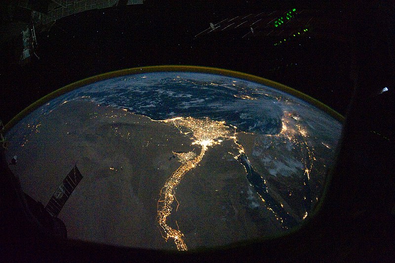
English: In this view of Egypt, we see a population almost completely concentrated along the Nile Valley, just a small percentage of the country’s land area. The Nile River and its delta look like a brilliant, long-stemmed flower in this astronaut photograph of the south-eastern Mediterranean Sea, as seen from the International Space Station. The Cairo metropolitan area forms a particularly bright base of the flower. The smaller cities and towns within the Nile Delta tend to be hard to see amidst the dense agricultural vegetation during the day. However, these settled areas and the connecting roads between them become clearly visible at night. Likewise, urbanized regions and infrastructure along the Nile River becomes apparent.
Another brightly lit region is visible along the eastern coastline of the Mediterranean—the Tel-Aviv metropolitan area in Israel (image right). To the east of Tel-Aviv lies Amman, Jordan. The two major water bodies that define the western and eastern coastlines of the Sinai Peninsula—the Gulf of Suez and the Gulf of Aqaba—are outlined by lights along their coastlines (image lower right). The city lights of Paphos, Limassol, Larnaca, and Nicosia are visible on the island of Cyprus (image top). Scattered blue-grey clouds cover the Mediterranean Sea and the Sinai, while much of north-eastern Africa is cloud-free. A thin yellow-brown band tracing the Earth’s curvature at image top is air-glow, a faint band of light emission that results from the interaction of atmospheric atoms and molecules with solar radiation at approximately 100 kilometres altitude. |
| Дата | |
| Ицц | NASA Earth Observatory |
| Автор | ISS Expedition 25 crew |
| Другие версии |
Производные работы от этого файла: Nile River Delta at Night cropped.JPG Also see http://earthobservatory.nasa.gov/IOTD/view.php?id=46820&src=eoa-iotd for annotated version, with features identified. |
| Местоположение камеры | | Это и другие изображения по их местоположению на OpenStreetMap |
|---|
Это изображение или видеозапись внесены в каталог Космического центра имени Джонсона НАСА под идентификатором (Photo ID): ISS025-E-9858. Этот шаблон не указывает на правовой статус данной работы. По-прежнему необходим нормальный шаблон лицензий. См. Commons:Лицензирование. Другие языки:
|
Image acquired with a Nikon D3S digital camera using a 16 mm lens, and is provided by the ISS Crew Earth Observations experiment and Image Science & Analysis Laboratory, Johnson Space Center.
Лицензия щвей
| Этот файл находится в общественном достоянии (англ. public domain), так как он был создан NASA (Национальным управлением по аэронавтике и исследованию космического пространства). Политика авторского права NASA гласит, что «Материал NASA не защищается авторским правом, если не указано иное». (См. Template:PD-USGov, страницу политики авторского права NASA или политику использования изображений JPL.) | ||
 |
Предупреждения:
|
| Аннотации | Это изображение аннотировано: Просмотреть аннотации на Викискладе |
Файлалъул история
Нажмите на дату/время, чтобы увидеть версию файла от того времени.
| Къо-моцӀ/мехх | Миниатура | Роценал | ГӀахьалчи | Комментарий | |
|---|---|---|---|---|---|
| гьанжесеб | 12:51, 8 новембер 2010 | | 4256 × 2832 (2,05 Мб) | Originalwana | {{Information |Description={{en|1=In this view of Egypt, we see a population almost completely concentrated along the Nile Valley, just a small percentage of the country’s land area. The Nile River and its delta look like a brilliant, long-stemmed flow |
Файл хӀалтӀизаби
Следующая страница использует этот файл:
Файлалъул глобалияб хӀалтӀизаби
Гьаб файл хаду рехсарал викиязда хӀалтӀизабула:
- af.wikipedia.org-лда хӀалтӀизаби
- arz.wikipedia.org-лда хӀалтӀизаби
- bg.wikipedia.org-лда хӀалтӀизаби
- bs.wikipedia.org-лда хӀалтӀизаби
- cs.wikipedia.org-лда хӀалтӀизаби
- el.wikipedia.org-лда хӀалтӀизаби
- en.wikipedia.org-лда хӀалтӀизаби
- en.wiktionary.org-лда хӀалтӀизаби
- es.wikipedia.org-лда хӀалтӀизаби
- ha.wikipedia.org-лда хӀалтӀизаби
- he.wikipedia.org-лда хӀалтӀизаби
- incubator.wikimedia.org-лда хӀалтӀизаби
- ln.wikipedia.org-лда хӀалтӀизаби
- ml.wikipedia.org-лда хӀалтӀизаби
- no.wikipedia.org-лда хӀалтӀизаби
- sd.wikipedia.org-лда хӀалтӀизаби
- sk.wikipedia.org-лда хӀалтӀизаби
- sl.wikipedia.org-лда хӀалтӀизаби
- sq.wikipedia.org-лда хӀалтӀизаби
- sq.wikiquote.org-лда хӀалтӀизаби
- sr.wikipedia.org-лда хӀалтӀизаби
- sv.wikipedia.org-лда хӀалтӀизаби
- ta.wikipedia.org-лда хӀалтӀизаби
- th.wikipedia.org-лда хӀалтӀизаби
- tr.wikipedia.org-лда хӀалтӀизаби
- uk.wikipedia.org-лда хӀалтӀизаби
- ur.wikipedia.org-лда хӀалтӀизаби
- vi.wikipedia.org-лда хӀалтӀизаби